
Marsdiep Route (blue)
Rate this route
Discover Den Helder through 10 distinctive locations
Fishermen, lifeboat crews, shipwrights and the navy have transformed the village of Helder into a town over the past 200 years. Den Helder enjoyed prosperous years until the Second World War. After the war, the heavily bombed town had to be rebuilt. New neighbourhoods were added and the naval dockyard changed. Even so, Den Helder remains a town with a strong connection to the sea.
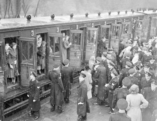
From Den Helder station, the route follows the blue arrows of the Marsdiep route and includes short audio features about topics such as life in the Visbuurt and work at the Rijkswerf. It also recalls the story of a young woman travelling to Den Helder on a crowded special excursion train to attend the annual gala at the Royal Netherlands Naval College. The route offers a glimpse of the past, while also showcasing the city’s renewal, taking in the impressive former naval dockyard Rijkswerf Willemsoord and the open sea air on the dyke. Plenty of terraces along the way offer a place to sit and relax.
The route forms a circular walk. From the station, it runs along the Beatrixstraat towards Willemsoord, then across the former dockyard to the dyke. It continues to the site of the former ’t Huys Tijdverdrijf and returns to the station through the Stadspark. Along the way, it introduces stories from local residents, lifeboat crews, dockyard workers and beachcombers. The total distance is just over 4 km. Watch a preview in this video!
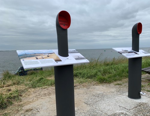
See the map for the locations of all the storytelling points along the route.
-
 To add this route in the app: scan the QR code from within the app. or enter the route number 56398 in.
 - 4.10 km
-
 Closed route
-
 Soon-to-be closed route
-
 Reports
-
 Hike point
-
 Starting point
-
 One-way path

| From | To | Segment length | Marking(s) | Characteristics | Reports |
|---|---|---|---|---|---|
|
Startpunt willemsoord |
0.81 km |
|
|
||
| 0.11 km |
|
|
|||
| 1.24 km |
|
|
|||
| 0.82 km |
|
|
|||
|
Starting point den helder station |
0.12 km |
|
|
||
|
Starting point den helder station |
0.53 km |
|
|
||
|
Startpunt willemsoord |
0.47 km |
|
|