
Gele route vanaf startpunt Wijk aan Zee
Average
1 Ratings
Rate this route
Dogs are allowed to be off-leash in certain parts of this route. Specific areas are indicated by signage from the municipality or land manager. Always follow the rules at the location and clean up after your dog.
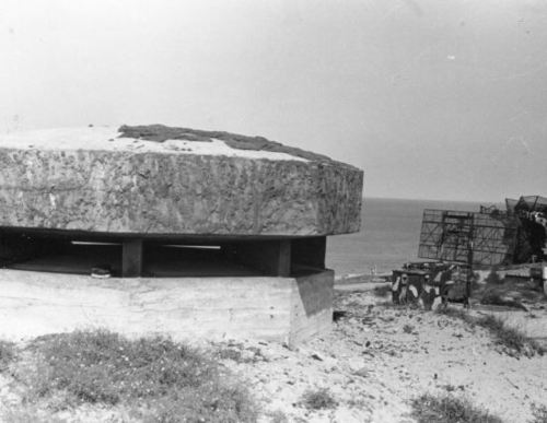
De gele route loopt om de restanten van de radarpost van de Atlantikwall heen.
In het duinlandschap rond Wijk aan Zee herinneren enkele bunkers nog aan de Atlantikwall, gebouwd door het Duitse bezettingsleger tussen 1940 en 1944. Dit zogenaamde Seefront IJmuiden strekte zich uit langs de kust van Heemskerk tot Bloemendaal en waren onderdeel van de Atlantikwall, de bijna 2500 km lange verdedigingslinie van de Noordkaap tot de Spaanse grens. Deze kustverdededigingswerken, hadden ten doel de haven van IJmuiden en het Hoogovenbedrijf te beschermen tegen aanvallen van de geallieerden.
Honden zijn aangelijnd toegestaan.
-
 To add this route in the app: scan the QR code from within the app. or enter the route number 10990 in.
 - 1.64 km
-
 Closed route
-
 Soon-to-be closed route
-
 Reports
-
 Hike point
-
 Starting point
-
 One-way path

| From | To | Segment length | Marking(s) | Characteristics | Reports |
|---|---|---|---|---|---|
|
Startpunt wijk aan zee |
0.14 km |
|
|
||
| 0.21 km |
|
|
|||
| 0.1 km |
|
|
|||
| 0.87 km |
|
|
|||
| 0.32 km |
|
|
|||
|
Startpunt wijk aan zee |
0.14 km |
|
|